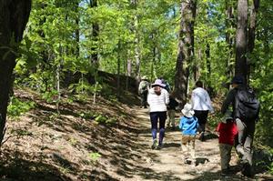
News: Places to walk, explore, hike, &/or bike while keeping your social distance
| Date Published |
Author |
| 4/15/2020 12:00:00 AM |
Jeanne Scigliano |
Please check links for the most up to date information on closures and conditions
We know that physical activity and time in the outdoors is beneficial to body, mind, and spirit. In our busy lives before the pandemic, we might not have been aware of all the wonderful, local places you can go and immerse yourself in nature! To assist you now, we have compiled a list with links of nearby locations with trails for you and your household to experience.
Plan ahead before you go:
- Research the web site for each of these prior to heading out to ensure they are still open to the public which they were at time of publication; in addition, many of these places have a Facebook page which is not linked here, but does have helpful up to date conditions posted by recent visitors! If you find anything on this list that has closed; please let us know. We will cross them out and mark in red, but we will keep them on the list for the future so you have the reference for better days ahead!
- Dress for the weather
- Bring :
- Your own food and drinks
- Your own garbage bag; plan to carry in carry out as most places have removed garbage pails to support the safety of their Maintenance staff
- Hand Sanitizer
- Consider the timing … so you schedule around your personal needs as public bathrooms are closed
- How long it will take to get there and get back?
- How long you plan to be there?
- Go solo with only the people you live with; do not plan to meet up with friend or family
- Let someone outside your immediate household know where you plan to go and let them know when you return
At destination
- If the parking lot is full, leave and choose another place; many venues are controlling the number of people visiting a site, by limiting the parking – respect the management and go elsewhere for your safety and that of other visitors
- When hiking/walking someplace new, I have found it valuable to set the timer on my phone at 30 minutes; when it rings I turn around ensuring the walk part of my outing is one hour, leaving me time to return home to attend to my personal needs
- Maintain social distancing keeping 6 feet or more between you and people who are not members of your household; step off trails to allow others to pass
Local trails some paved most wooded!
- Beekman Recreation and Parks
- Dutchess County Parks:
- Bowdoin County Park, Sheafe Road, Wappingers Falls trail map
- Wilcox Memorial Park, Route 199 Standfordville, trail map
- Dutchess County Rail Trail access points as shown on this map and including:
- Hopewell Junction by Daddy-O’s
- Diddell Road
- Behind Gold’s Gym
- Overocker Road
- Harlem Valley Rail Trail from Amenia to Millerton with multiple access points including:
- Wassaic Train Station, Route 22 Amenia
- Mechanic St. Amenia
- Sharon Station Road, Amenia
- Coleman Station Road, Amenia
- Route 44, Millerton
- Trails in nearby Towns:
- Michael Ciaiola Conservation Area, on the north side of Haviland Hollow Rd., in Patterson, NY next to the CT border, has over 800 acres with a hiking trails and great gorge waterfall
- Stone Church, Route 22, Dover has an Info Booklet
- Hyde Park Walkabout Trails Map has multiple opportunities – remember to check each site for possible COVID related closures
- Pawling Nature Reserve , Quaker Lake Road, Pawling, over 1000 acres with a variety of trails and a gorge as shown on this map
- Cary Institute of Ecosystem Studies in Millbrook, has made trails and roadways available as shown on this trail map and due to pandemic have now made a ONE WAY TRAIL MAP – please follow the arrows
- Putnam Trail Way a rail trail through Putnam County with multiple access points as shown on this brochure/map
- Trails in nearby NY State Parks
- Trails nearby brought to us by Scenic Hudson:
- Roger Perry Memorial Reserve, a Nature Conservancy site on Sand Hill Rd., Dover, has a short, easy loop trail
- Poet’s Walk, 776 River Road, Red Hook – has a Guide
- Black Creek Preserve, Winding Brook Rd., Esopus has a map of trails
- Red Wing Recreation Area Billings, on Route 82, just north of Route 55 and here’s a trail guide
- Trails on NYS Department of Environmental Conservation lands – some good for hiking on marked trails, some for woodland exploration – do your research before you go!
- West Mountain Multiple Use Area, park at the end of Gardner Hollow Road in Poughquag for 4 miles of multi-use trails traversing the 830 acre property which straddles the Beekman/Dover Town Line, Trail maps
- Depot Hill Multiple Use Area<, accessed by 2 parking areas on Depot Hill Road, Poughquag consists of 267 acres with unmarked trails and the Appalachian Trail; click here for map
- Great Swamp Wildlife Management Area, off Cornwall Hill Rd., Patterson, NY consists of 444 acres and a trail good for bird watching
- Cranberry Mountain Wildlife Management Area, over 1,000 acres off Stagecoach Rd, in Patterson, with trails as show on this map and a review and guide to a 6 mile hike
- Ninham Mountain Multiple Use Area, Gypsy Trail Road, Kent (Carmel zip code), NY has over 1000 acres with a number of trails as shown on this map, including one that goes to a Fire Tower – Please note – all Fire Towers are closed during the pandemic
- White Pond Multiple Use Area, parking along White Pond Rd, Kent, (Carmel zip code) NY, 263 acre parcel includes 129 acre pond for fishing and paddling, and trail around pond for hiking
- Taconic Hereford Multiple Use Area on the Taconic just north of Lagrange in Pleasant Valley on the east side of the parkway has many trails on this map
- Wassaic Multiple Use Area in Amenia trail map, reviews indicate you should park at the southern access and walk down to the Ten Mile River
- Trails on National Park Service Sites in Hyde Park:
- Trails on Estates in the Hudson Valley:
To reduce density the following trails are Closed: